


autrans - parking jean babois-refuge de la moliére

maupassant38
User
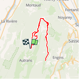

Length
35 km

Max alt
1644 m

Uphill gradient
890 m
Km-Effort
47 km

Min alt
1190 m

Downhill gradient
891 m
Boucle
Yes
Creation date :
2019-02-22 22:31:25.53
Updated on :
2019-02-22 22:31:25.541
2h38
Difficulty : Medium

FREE GPS app for hiking
 SityTrail
IGN / Geographical institutes
SityTrail Plus
The world is yours!
About
Trail Mountain bike of 35 km to be discovered at Auvergne-Rhône-Alpes, Isère, Autrans-Méaudre en Vercors. This trail is proposed by maupassant38.
Positioning
Country:
France
Region :
Auvergne-Rhône-Alpes
Department/Province :
Isère
Municipality :
Autrans-Méaudre en Vercors
Location:
Autrans
Start:(Dec)
Start:(UTM)
700727 ; 5007671 (31T) N.
Comments